
Sierra Bermeja Natural Protected Site
MALAGA – The largest rock peridotite massif in Europe.


Peridotite rocks
Maritime pine
Spanish Fir (Pinsapos)
Garnets and diamonds pseudomorphs
Views over the Mediterranean
Sierra Bermeja, from arabic Djebel Al Jamra, the Red Mountain, whose name is inspired by the coloration of the soil and the rocky substrate. It is located in Costa del Sol‘s hinterland, between Manilva to the west, Estepona and Marbella in the east. This rugged territory extends inland between the villages of Casares and Istán and is formed by several mountain ranges or elevations such as Los Reales, Anícola, Palmitera, Apretaderas and Sierra Real.
The Sierra covers a total area of 30,000 ha (300 km²), is protected under the figure of natural landscape and is currently the subject of a national park declaration project. Its climax rises to 1,508 meters (4,947 ft) at Pico Abanto, an almost anonymous peak eclipsed by its neighbor, Pico Torrecilla, just five kilometers away and undisputed summit of the Sierra de Las Nieves.
Sierra Bermeja is a unique outcrop of ultramafic rocks, peridotites and serpentines (resulting from the alteration of peridotite) that represent less than 1% of the earth’s surface and which unusual geochemistry triggers biodiversity hot spots. The red color comes from the iron oxide produced by the alteration of the peridotite exposed to atmospheric agents. The soils lack essential elements: Ca, K and P, but are endowed with heavy metals, nickel and aluminum … it goes without saying that they are not very fertile! Under what strange circumstances could a part of the upper mantle (see note) arise and be exposed to the world? It was through the movements of the tectonic plates, the collision of the European and Africa plates, that gave rise to the Alps, and also with the Alboran microplate.

VIew from the Genal Valley on the most unique elevations of Sierra Bermeja Protected Natural Site: Los Reales (1,443 m). The mountain isolates the mountain villages, yet less than 20 kilometers from the coastal town of Estepona.
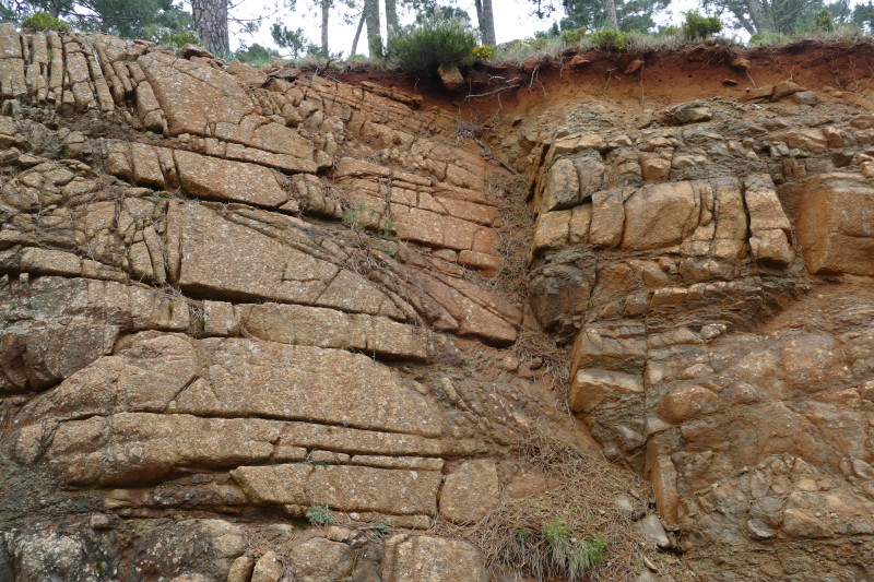
The action of the water alters the peridotite rock, oxidizes the iron minerals and gives it its characteristic red color.
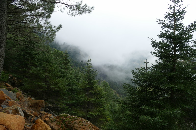
The humid climatic conditions of the northern slope of Los Reales contrast with the aridity of the surroundings and favor the presence of a relict forest of Spanish fir trees, the pinsapos.
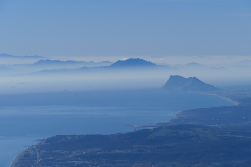
The coastal sierras of the province of Malaga offer the most attractive views the closer you get to Gibraltar.
The most emblematic summit called Los Reales de Sierra Bermeja (1,449 m / 4,753 ft) is an imposing relief located just 8 kilometers away from the coast. It is covered with conifers and often wraped with fog which brings humidity and high rainfall. A forest of pinsapos (Abies pinsapo) covers the northern part of the summit that is transformed further down into a large forest of native pine trees (Pinus pinaster) present for over 10,000 years. In some streams, garnets and diamond pseudomorphs can be found (no commercial value).
The combination of peridotites, subhumid Mediterranean climate and relict coniferous forests is unique in the world. Add the magnificent panoramas of Africa, Gibraltar, the coastal mountains and the sea. Definitely an excursion that cannot be missed.
We offer a Málaga wildlife tour which is perfect to explore ist best natural areas and taste the Mediterranean feel.
Note. Remember that the internal structure of the Earth is composed of several layers with heterogeneous densities and chemical compositions: the core, the mantle and the earth’s crust. The inner core is dense, liquid and metallic. The mantle is a basic material rich in olivine and pyroxene (iron and magnesium). As for the earth’s crust, we can differentiate the continental crust (15 to 80 km deep), composed of acid-rich granite rocks rich in silica, and the oceanic crust (5 to 7 km) that consists of basalts which are basic. To complicate the matter, consider the rigid envelope of the earth’s surface called lithosphere (“stone ball”) and divided into tectonic plates whose movements give rise to the continents. Lithosphere includes the earth’s crust and the outer part of the mantle: the upper mantle, whose rocks, peridotites, are rich in olivine, magnesium and iron (ultramafic) and very poor in silica (less than 45% of its mass).
Sierra Bermeja, from arabic Djebel Al Jamra, the Red Mountain, whose name is inspired by the coloration of the soil and the rocky substrate. It is located in Costa del Sol‘s hinterland, between Manilva to the west, Estepona and Marbella in the east. This rugged territory extends inland between the villages of Casares and Istán and is formed by several mountain ranges or elevations such as Los Reales, Anícola, Palmitera, Apretaderas and Sierra Real.
The Sierra covers a total area of 30,000 ha (300 km²), is protected under the figure of natural landscape and is currently the subject of a national park declaration project. Its climax rises to 1,508 meters (4,947 ft) at Pico Abanto, an almost anonymous peak eclipsed by its neighbor, Pico Torrecilla, just five kilometers away and undisputed summit of the Sierra de Las Nieves.
Sierra Bermeja is a unique outcrop of ultramafic rocks, peridotites and serpentines (resulting from the alteration of peridotite) that represent less than 1% of the earth’s surface and which unusual geochemistry triggers biodiversity hot spots. The red color comes from the iron oxide produced by the alteration of the peridotite exposed to atmospheric agents. The soils lack essential elements: Ca, K and P, but are endowed with heavy metals, nickel and aluminum … it goes without saying that they are not very fertile! Under what strange circumstances could a part of the upper mantle (see note) arise and be exposed to the world? It was through the movements of the tectonic plates, the collision of the European and Africa plates, that gave rise to the Alps, and also with the Alboran microplate.
The most emblematic summit called Los Reales de Sierra Bermeja (1,449 m / 4,753 ft) is an imposing relief located just 8 kilometers away from the coast. It is covered with conifers and often wraped with fog which brings humidity and high rainfall. A forest of pinsapos (Abies pinsapo) covers the northern part of the summit that is transformed further down into a large forest of native pine trees (Pinus pinaster) present for over 10,000 years. In some streams, garnets and diamond pseudomorphs can be found (no commercial value).
The combination of peridotites, subhumid Mediterranean climate and relict coniferous forests is unique in the world. Add the magnificent panoramas of Africa, Gibraltar, the coastal mountains and the sea. Definitely an excursion that cannot be missed.
Note. Remember that the internal structure of the Earth is composed of several layers with heterogeneous densities and chemical compositions: the core, the mantle and the earth’s crust. The inner core is dense, liquid and metallic. The mantle is a basic material rich in olivine and pyroxene (iron and magnesium). As for the earth’s crust, we can differentiate the continental crust (15 to 80 km deep), composed of acid-rich granite rocks rich in silica, and the oceanic crust (5 to 7 km) that consists of basalts and is basic. To complicate the matter, consider the rigid envelope of the earth’s surface called lithosphere (“stone ball”) and divided into tectonic plates whose movements give rise to the continents. Lithosphere includes the earth’s crust and the outer part of the mantle: the upper mantle, whose rocks, peridotites, are rich in olivine, magnesium and iron (ultramafic) and very poor in silica (less than 45% of its mass).


